Hurricane Francine bearing down on Louisiana; Landfall early Wednesday evening
Hurricane Francine will roll onshore in south-central Louisiana early Wednesday evening with significant risk to lives and property associated with storm surge, strong winds and flooding rainfall.
 Lt. Gov. Nungesser urges safety as Francine begins to make landfall in Louisiana00:1903:34
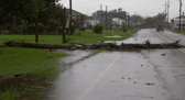
Aaron Rigsby reports from Houma, Louisiana, where preparations are in place ahead of Francine’s landfall.
An area under AccuWeather meteorologists’ radar for weeks recently gave birth to Tropical Storm Francine, which is forecast to strike Louisiana as a hurricane early Wednesday evening with dangerous storm surge, damaging winds and flooding rainfall.
“Francine had an opportunity to strengthen further during the day Wednesday, but wind shear continued to keep the hurricane officially in check at Category 1 status on the Saffir-Simpson Hurricane Wind Scale,” AccuWeather Lead Hurricane Expert Alex DaSilva said at mid-afternoon on Wednesday, “There still are a few hours left for the storm to strengthen a bit before making landfall, but time was running out.”

This image of Francine was captured on Wednesday afternoon, Sept. 11, 2024, and shows the well-organized core of the hurricane and some effects of southwesterly wind shear, causing some lean to the northeast in the verticle structure. (AccuWeather Enhanced RealVue™ Satellite)
The latest on Francine
Francine became a hurricane on Tuesday evening with maximum sustained winds of 75 mph. By Wednesday morning, Francine had gained further wind intensity, with maximum sustained winds of 90 mph — just 6 mph shy of Category 2 intensity on the Saffir-Simpson Scale.

On Wednesday afternoon the hurricane was moving northeast at 16 mph, and it is forecast to pick up additional forward speed. The eye of Francine was located less than 75 miles to the southwest of Morgan City, Louisiana, and less than 145 miles to the southwest of New Orleans, but areas of heavy rain and gusty winds extended well to the north and east of the center.
A hurricane warning was in effect from the Texas/Louisiana state line to Grand Isle, Louisiana, and a tropical storm warning was in effect for the Louisiana coast from Grand Isle through Lake Pontchartrain. A tropical storm warning was also in effect for the southern Mississippi and Alabama coasts.

Peak wind gusts of Category 2 intensity (96-110 mph) were being reported at several stories above the surface over the Gulf of Mexico on Wednesday.
At this time, Francine is a 2 on the AccuWeather RealImpact™ Scale for Hurricanes, which gauges the risks to lives and property, damage to infrastructure, and economic loss due to wind damage and flooding from rainfall and storm surge. The Saffir-Simpson Hurricane Wind Scale only accounts for the sustained winds of a hurricane.

Louisiana to bear brunt of Francine’s wind, rain and storm surge
The most dangerous aspect of a landfilling hurricane is the rapid rise of coastal waters that penetrate inland, known as storm surge.
“AccuWeather meteorologists, based on the track and intensity of Francine, are projecting a storm surge of 6-10 feet along much of the Louisiana coast with a pocket of 10-15 feet on some of the inland bays in south-central Louisiana,” DaSilva said.

“As long as Francine tracks into central Louisiana, the storm surge in New Orleans, including Lake Pontchartrain, should be 3-6 feet. Should Francine track a bit farther to the east, which some data suggests, then the storm surge could be greater in southeastern Louisiana,” DaSilva added.
Francine will pack a punch in terms of strong winds with an AccuWeather Local StormMax™ gust of 130 mph along the south-central Louisiana coast.

A broad zone of wind gusts frequenting 60-80 mph will occur over much of southern and eastern Louisiana and southern and central Mississippi. Winds of this intensity and even lower at sustained speeds are plenty strong enough to knock down trees and trigger regional to widespread power outages, including in New Orleans, Baton Rouge and Lafayette, Louisiana, as well as Jackson and Biloxi, Mississippi.
Wind gusts of 100-120 mph are anticipated from Morgan City to near New Iberia and Houma, Louisiana.

Where tornadoes occur, damage can be more severe and pose a greater risk to lives and property.
The highest risk of inland tornadoes will be north and east of the storm center. Because some dry air has become entrained into Francine’s circulation, it may increase the number and intensity of severe thunderstorms, which could boost the number of tornadoes beginning Wednesday and possibly continuing into Friday.

The most far-reaching impacts from Francine will be heavy rainfall, which can trigger everything from small stream and low-lying area flooding to significant rises on some of the south-central United States region’s secondary rivers and bayous.
A broad area where 4-8 inches of rain will fall is likely, centered on the Mississippi Delta region, with 8-12 inches of rain and an AccuWeather Local StormMax™ rainfall of 24 inches forecast in southern Louisiana.

Rain, water level rise needed on Mississippi River for barge transport operations
“Water levels on the Mississippi River have plummeted in recent weeks and were at near-historic lows once again for the third year in a row,” AccuWeather Chief On-Air Meteorologist Bernie Rayno said.
Areas of significant drought have been expanding over the Mississippi Basin.

The rain and reasonable water level rise on the Mississippi River are much-needed for tug and barge transport to operate efficiently. The waterway is invaluable for the low-coast transport of grains and other commodities.
Since the amount of rain will tail off quickly over the Ohio River Valley and no rain from Francine will reach the upper Mississippi Valley, not enough of a water level rise, or one that lasts very long, is likely to occur on the mid-Mississippi stem. The Ohio River contributes more than the main stem of the Mississippi River at the Ohio-Mississippi River confluence.
Slow movement of Francine while inland will boost rainfall amounts over the South Central region.

However, Francine’s northward movement into much of the Midwest may be blocked by high pressure. As a result, the northward extent of the system’s moisture, as a tropical rainstorm, will likely diminish.
Could a spinoff tropical storm develop?
As Francine loses wind intensity over the interior Central states, a new tropical concern may spin up just off the Carolina coast this weekend.
That feature has the potential to evolve into a tropical storm this weekend and drift inland over the Southeastern states early next week packing torrential rain, severe thunderstorms and strong winds.
The next name on the list of Atlantic tropical storms is Gordon.
Francine to affect petroleum operations in Gulf
It has been a few years since the petroleum industry in the central Gulf of Mexico had to weather a hurricane and Francine will lead to disruptions.
How strong Francine becomes will determine the scope of impact on the petroleum industry over the Gulf of Mexico and refinery operations along the Gulf coast.

However, the strengthening tropical cyclone will likely have some negative effect on operations, which could be reflected as higher prices at the pump for a time.